The Lawrence Hopewell Trail
As the weather warms, we are all anxious to get outside and the Lawrence Hopewell Trail is one place to do it. Designed primarily as a bicycle trail, it is also open to foot traffic. The section from Meadow Road in Lawrence Township to Weldon Way in Hopewell Township is complete and does not involve riding on any heavily traveled roads so it is perfect for families and recreational riders. Check lhtrail.org for maps.
(Please note that the Lawrence Hopewell Trail also runs north from Meadow Road to the ETS campus near Princeton Township. This section is not considered below.)
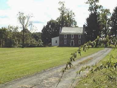
The parking area near Meadow Road is associated with Lawrence Historical Society’s Brearley House. Look for the date 1761 in the brick on the east gable. This building reflects the style of an 18th century English Manor house scaled down for an American farming family. The bricks were made from local clay and probably fired in a kiln on the property. If you have time, take the short spur which connects with the Delaware and Raritan Canal towpath. This area was once the Great Meadow, a farming and grazing land of the Leni-Lanapi, but has become a wetland after two centuries of canal and road construction.
Taking the LH Trail west, you will cross Princeton Pike and follow the Lewisville Road to the Lawrenceville School. The Trail passes through the school grounds, part of which are a National Historic Landmark and include an area designed by Frederick Law Olmstead (famous as the designer of New York’s Central Park).
After leaving the Lawrenceville School, you will cross Route 206 in the historic village of Lawrenceville. The Trail takes a turn down a short stretch of the former Johnson Trolley Line before proceeding up Craven Lane and through Lawrenceville’s Village Park, across Keefe Road and into Mercer Meadows (part of Mercer County’s park system). This section of the Park includes the Pole Farm. In the 1920’s, American Telephone & Telegraph purchased several family farms and clear-cut the land to erect steel and rhombic antennas, creating the largest transmission station in the world. Local livestock grazed beneath the rows of towers which came to be called the Pole Farm.
After crossing Blackwell Road, the Trail passes through the grounds of the restored Hunt House, now the Mercer County park office. The house dates to 1760-1790 with later 18th and 19th century additions. In addition to the house, there is a visitor center.
A bit further on, you will loop around Willow Pond and then come to Rosedale Lake with its fishing pier and canoe/kayak launch. Picnic tables are available and children can use the nearby Treehouse Playground. There is also an off-leash dog park.
After crossing Federal City Road, you will find the Mercer Educational Gardens and the Equestrian Center with over 200 acres for horseback riding, bird watching and hiking. There is also an equine-themed play area for kids. The Trail re-crosses Federal City Road and passes through the Ecological District of Mercer Meadows and Old Mill Road, the site of an historic Hopewell Valley saw and grist mill. It then crosses Pennington-Rocky Hill Road. Here you have a choice. You can follow the main Trail past Bristol-Myers Squibb’s Hopewell campus up to Wargo Road or you can turn left and follow a short spur down into the historic town of Pennington. A printable map of Mercer Meadows is available here.
After crossing Federal City Road, you will find the Mercer Educational Gardens and the Equestrian Center with over 200 acres for horseback riding, bird watching and hiking. There is also an equine-themed play area for kids. The Trail re-crosses Federal City Road and passes through the Ecological District of Mercer Meadows and Old Mill Road, the site of an historic Hopewell Valley saw and grist mill. It then crosses Pennington-Rocky Hill Road. Here you have a choice. You can follow the main Trail past Bristol-Myers Squibb’s Hopewell campus up to Wargo Road or you can turn left and follow a short spur down into the historic town of Pennington. A printable map of Mercer Meadows is available here.
Karen at Hopewell


Comments
Post a Comment